Early History
Lochalsh was for centuries part of the lands of the MacDonalds, who were Lords of the Isles. However, it was forfeit to the Crown 1494 after MacDonald revolts, and it was subsequently MacKenzie land, although under Matheson (or MacMathan) control. Some parts of Lochalsh belonged to the MacDonells of Glengarry for a time, until after their defeat at Strome Castle 1602, when the King granted these lands to the MacKenzie lords of Kintail. In 1625 Colin MacKenzie was given the hereditary title Earl of Seaforth, and Lochalsh remained part of their lands until Francis Humbertson MacKenzie (the last of the Seaforths) was forced to sell parts of his lands to pay off debts. Sir Hugh Innes bought Lochalsh in 1801.
Battle at Sail Fearna
The burial mound at Achmore bridge may be associated with a battle which occurred in Srath Ascaig in the fifteenth century. When the clan chief Alastair Mhic Ruari Matheson was beheaded by James I in 1427, his widow married Angus MacLeod of Assynt, who usurped the family patrimony of Lochalsh. Alastair's heir John fled, but returned on manhood reclaiming his land. Angus MacLeod then fled to Lewis, but soon returned and a battle was fought at Kirkton at which the MacLeod force was routed. But Angus escaped to return for a second attempt, this time landing at Fernaig, where a battle was fought against John Matheson at Sail Feara (just above the stepping stones, on the south side of the river at Fernaig). MacLeod was killed, and the slain are said to be burried in the mound in the field by Achmore bridge.
Pont’s Map
One of the earliest maps of Lochalsh is by Pont (ca 1583-1601), titled “Part of the Back Syde of Rosse”, and is a pretty rough sketch intended to be used to make a finer copy later. It does have some interesting detail; Strahaifkeg (Strath Ascaig) and Ardinerrurr (Ardnarff) are shown, and an indication that the coast was well wooded. You can see Pont's map at www.nls.uk/pont/specialist/pont04r
Strome Castle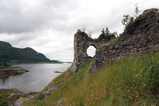
In the spring of 1602 MacKenzie gathered an army of his own men plus Matheson, MacRae and MacLennan supporters, and laid seige to Strome Castle. It was a stronghold of the MacDonells of Glengarry, with whom there was an ongoing feud. The seige went on for weeks, until Donald MacRae and some Matheson women, who were prisoners inside the castle were able to pour water on the gunpowder, making it useless.
Donald MacRae managed to escape the castle by jumping off the wall onto a dung heap, and told the MacKenzies, who had decided to give up the siege, about the wet gunpowder. So the Kintail men returned to the attack and the MacDonells were forced to surrender. The defeated force was allowed to take their possessions and depart in peace. The castle was blown up, and the MacDonell’s power in the area was over. A little while later Kenneth MacKenzie of Kintail received a royal charter for the lands of Lochalsh and Lochcarron, previously belonging to Glengarry.
1688 Fernaig Manuscript
The Fernaig Manuscript was so called because for most of the nineteenth century, it was in the possession of Mr Matheson of Fernaig. It is a collection of poems written in a phoenetic gaelic, and was complied by “Donnchadh MacRath”, or Duncan MacRae of Inverinate (clan chief). He was known as Donnchadh nam Pios (Duncan of the silver plate) and he was a harper and bard. The manuscript consists of a small notebook of 36 pages, seven inches by three, and the contents were written down between 1688 and 1693. Over the years there have been many translations and transcriptions from this important, historic manuscript, and much written about it. See The Companion to Gaelic Scotland for more information.
Reliquiae Celtcae (1894), which contains a transcription and some translation into modern gaelic, includes this: “Duncan MacRae came to a tragic end. In company with an attendant, who is said to have possessed the fatal gift of “or na h-Aome” – a power by which he could cause the death of anyone seen by him crossing a stream on Friday, MacRae was returning from Strathglass with the title deeds of the Affric lands in his possession. In attempting to cross the Connag River at Dorisduan, which was in high flood, he was carried away and drowned, for his attendant could not help him, nor could he help looking at his master battling with the flood, and, as he possessed the fatal power of drowning people in such circumstances, he caused his masters death.”
Glas na Muclach
This name, meaning “green place of pigs” is the name of the green slope to the west of Braeintra. This land was granted to Murdoch Matheson of Achmore in the 17th century, for diving to retrieve a silver hilted sword lost overboard by MacKenzie of Kintail. The skerry near where it happened is called Sgeir ‘Chlaidheamh (rock of the sword), just north of Plockton. Unfortunately Murdoch had no written charter for the land and the family lost it after his son Ewan died.
The Seer’s oak (NG862327)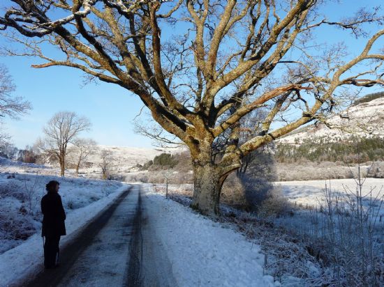
This large oak tree, at a passing place on the road between Achmore and Braeintra, is associated with a prophesy of Coinneach Odhar, the Brahan Seer. When two Achmore men can join hands around the tree, it will be a disastrous day for the district. Many prophesies have been attributed to Coinneach Odhar erroneously, being the most famous seer, and it seems likely that this is has a more recent origin, unless it originally referred to another tree, with the present one growing up to replace it. The Seer lived in the 17th century, so the tree would have to have been large 350 years ago. The girth of the tree, measured in 2002 was 4.54metres, or about 14ft 11inches, which might suggest an age of over 200, maybe getting on for 300. However recent tree coring work has shown that it is virtually impossible to date a tree from its size. Some of the oldest trees in Scotland are actually quite small. It is a healthy tree, and hopefully has many years to go. In 2003 the tree featured in the book “Heritage Trees Of Scotland”.
General Roy's military survey
Because of the Jacobite rebellions of the eighteenth century, the Hanovarians took measures to try to control the Highlands. These included building forts (e.g. George, Augustus and William) and barracks (e.g. Glenelg), and as much of the Highlands were unfamiliar to government forces, General Roy was commissioned to map the country. The Achmore and Stromeferry area was mapped in about 1770, but the results appear to have been less accurate than maps produced for other places. The map shows “Fairnack” (Fearnaig) and two obsolete hill names: “Ourduich” and “Ourambu”. You can see the maps at www.nls.uk/maps/roy.